Roger Donne’s Miscellany |
|
|
About This Site |
Cycling |
Family History |
Contact Me |
Site Map |
Links |
On the Devon Bank of the Tamar
St Budeaux
St. Budeaux lies in the county of Devon, although up until 1895, a small part of it at Saltash Passage was claimed to belong to the Duchy of Cornwall, and was known as the Cornish Patch. My family connections with St. Budeaux stretch back over 200 years, and it was here that I spent my early life.
|
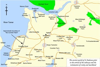
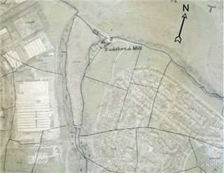
This sketch map shows the parish before the advent of the railways and before a substantial amount of land was reclaimed from the river at Ernesettle and the creeks, particularly at Weston Mill Lake were filled in. Click here to view the enlarged map in a separate window |
An account of St Budeaux published in 1856 records that at that time the population of the parish had just reached 1,000, of whom only 30 or so were entitled to vote. At that time, the parish of St Budeaux was rich farming country centred around the ancient parish church perched high above the river Tamar. The parish itself stretched over 2,500 acres of land and included the hamlet of King's Tamerton, half-a-mile away; Salt Ash (Saltash) Passage, one mile west; Honicknowle, Knackersknowle (Crownhill) and Whitleigh to the east. Of this land 100 acres between Ernesettle and Saltash Passage had recently been reclaimed from the bed of the river.
A small area around Saltash Passage was known as 'the Cornish Patch' since it was historically part of Cornwall until transferred to the county of Devon in 1844, and to the parish of St Budeaux in 1895. It is mentioned speciifically in the Reform Act of 1832 (which defined the divisions for parliamentary elections) in which it is described as ''A small Part of the Parish of St. Stephens by Saltash which lies on the Eastern Side of the River Tamar'. The Reform Act did not change any parish or county boundaries, however. That was was left to subsequent Acts of 1836 and, in particular, the Counties (Detached Parts) Act of 1844 which prescribed the incorporation of detached parts of a county into the county defined by the parliamentary division to which they were assigned in the Reform Act. However, it seems that the status of the Cornish patch remained ambiguous until 1895 before finally being transferred from St. Stephens by Saltash to St. Budeaux parish. Interestingly, and confusingly, in the tithe apportionment for St. Budeaux parish prepared in 1842, St. Budeaux is described as being in the counties of Devon and Cornwall, and properties in the Cornish patch are actually assessed for the purposes of tithe valuation within the parish of St. Budeaux.
A narrow lane (Cliffe Lane) led up the hill to St. Budeaux from the farms on the Tamar at Ernesettle. The two farms, Great Ernesettle and Little Ernesettle were both named after William Ernstell, a freeholder of Budshead, who owned land here in 1428. In the middle of 19th century there were more than ten farms in St. Budeaux, including part of the Manor of King's Tamerton with Bartons and Manor Houses at Barne and Kinterbury and part of the Manor of Budshead.
|
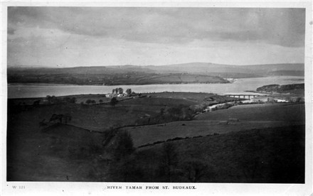
This postcard from my collection, dated to 1917 by the message on the reverse, shows a view of the Tamar from St Budeaux without the modern housing and industrial development; the farm buildings at Little Ernesettle can be seen in the centre of the picture and the railway bridge across the mouth of Tamerton Creek at the far right. |
|
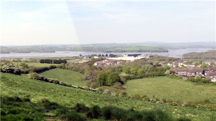
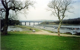
This modern photograph taken in 2011 from the north side of the churchyard shows a view which is still broadly similar to the 1917 postcard, showing that some green fields still remain in St Budeaux, although the view is now dominated by the industrial-type structures at Ernesettle and the housing which spreads down the hill towards Budshead and Tamerton Lake. |
For many centuries there was little major development in the parish. It is recorded that as late as 1781 there were less than 400 people living in the area, occupying only 77 households between them. However, change was on the way. In 1805 the Government purchased 15 acres of land at Bull Point, then known as Kinterbury and established there the Kinterbury Powder Works. Later, in 1830, the Keyham Powder Magazine was moved from its location in Morice Town and a magazine with the larger capacity then required was built next to the Powder Works.
Later, in the 1860s, the parish saw more military changes with the construction of several fortifications known as Palmerston's Forts (or Follies since the strategic need they served, to fortify towns against a French invasion, had disappeared by the time they had been constructed). In St. Budeaux, the forts faced north, to guard against a invading force attacking from the land, and included at Ernesettle, Ernesettle Battery and Agaton Fort; at Honicknowle, Knowle Battery and Woodland Fort; and further east, Crownhill Fort and Fort Austin. That this made an impact on the landscape can be judged by a report in the 'The Times' of 6 April 1861, which mentions that 'the erection of a fort at St. Budeaux... where about 120 acres of land may be required from Mr W. E. Elliott.' Not only was land required for the forts, but the fortifications were linked by massive banks and ditches, a portion of which survives to the west of St Budeaux parish church, and all were served by a military road which forms the basis of the modern routes in the area.
|
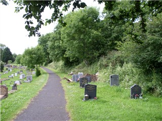
This photograph was taken in the overflow section of St Budueax Parish Churchyard, looking west, and showing the bank on the right of the photograph remaining from the subsidiary Palmerston fortifications |
Now both farmland and military structures are submerged in the vast and sprawling suburb of Plymouth, which has grown up over the last 100 years.
Old St Budeaux
The centre of settlement in St.Budeaux was originally around the parish church, standing on a splendid site overlooking the river Tamar. The church is famous for being the the place where Sir Francis Drake married Mary Newman, in 1569, and also as the burial place of his wife. The present building dates from 1563, although some sources say that it was built upon the site of an earlier church. However, H. Montagu Evans quotes a source saying that church was moved to its present site from a 'damp and unhealthy situration, near water', and goes on to suggest that the original church was actually at Budshead, quoting the antiquarian and traveller Leland, who, writing some 20 years before the foundation of the present church, says in his Itinerary when speaking of Tamerton Creek, that 'The creke goeth up to Mr Budocke's side wher is his manor place and St Budock chirch'. Be that as it may, the present church stands to one side of the remnant of the village green, not far from the route of the busy A38 as it passes through Plymouth (The Parkway) en route to the Tamar road bridge.
|
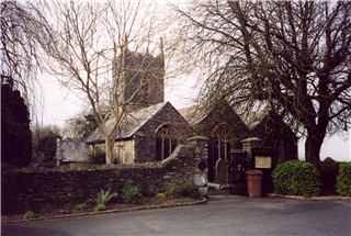
St Budeaux Parish Church, pictured in February 2003 |
|
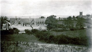
A postcard from my collection showing St Budeaux School and the parish church in the background circa 1910. The main road to Crownhill (formerly Knackersknowle) running in front of the school continues through open fields. |
Dating from 1717, the St. Budeaux Church of England Foundation School originally stood around the green. In 1860, this was moved to a splendid limestone building standing beside the original road to Crownhill. This building fell victim to the construction of the Parkway in its cutting through St. Budeaux.
Communication between St. Budeaux and Plymouth was originally through Crownhill, or Knackersknowle as it was then called. St. Budeaux had an importance beyond its agricultural significance because it lay on the main southern route into Cornwall from Devon and Plymouth. Historically,the route kept to high ground, running through Knackersknowle (Crownhill) and then through St. Budeaux and down the hill to Saltash Passage and the ferry crossing of the Tamar.
From Plymouth, a second, shorter, route went through Weston Mill near the head of a wide tidal creek, but before the building of a bridge at Weston Mill, this was only passable at low tide. This route led through Peter's Park Lane, across the 'Commons' where it was joined by the Crownhill road to Saltash Passage
In the course of time, Weston Mill Lake was eventually filled in and bridged and a route was established through the lower lying ground near to the Tamar. The head of the creek was originally bridged by a wooden bridge at Camels Head ('Shaky Bridge'), paralleling the earlier railway bridge opened in 1859 and which took Brunel's railway to the Royal Albert Bridge over the Tamar. With the construction of New Passage Hill at Devonport, a southerly route was established and the road bridges replaced by an embankment; further reclamation work has almost obliterated the creek, with the construction of the entrance to the naval base.
Budshead
The Manor of Budshead formed an important centre of business. Remains of the manor house and outbuildings can still be seen at the head of Budshead Creek, where it joins Tamerton Lake.
|
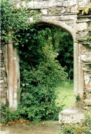
Very little of Budshead Manor House now remains. This handsome doorway was still standing in 2002. |
My own link with Budshead lies in Budshead Mill (sometimes written Butshead, Buttshead or Budds Head) where from 1860 to 1890, my ancestors, the King family, were millers. Budshead Mill was particularly interesting being a tide mill. operated by tidal waters trapped in the mill pond at high tide,and allowed to escape to drive the millwheels as the tide fell. Clearly, this was a 24 hour a day job, since the mill could only operate when the tide was low, whether that was in the day or at night. Local historian Marshal Ware recorded that Budshead Mill was fitted with three pairs of stones for grinding wheat, barley and oats, and was built by John Gonk in 1791 for George Leach, the owner of the farm, who rented the Mill and tidal basin of over 6 acres to him for a nominal consideration in the first three years. Subsequent owners were Richard Hall Cross of Pennycross, in 1798, followed by Lord Ashburton in 1840, and Earl Compton, his kinsman, succeeded him. His tenants were Walter King (1805-1869) followed by William King (1832-1912). William King retired from the milling business prior to 1887, when Budshead Mill was taken over by Harold Doney, the last miller to run the mill; it finally closed in 1927.
The Mill was admirably situated with regard to river transport links up and down the rivers Tamar and Tavy since it was situated just inside Tamerton Lake, just a few hundred metres from its mouth on the River Tamar and accessible on every high tide. Sailing barges plied their trade with the Mill, although in the final years of the Mill's operation navigation became more difficult with the building of a railway bridge across the mouth of Tamerton Lake. It was then necessary to lower the mast in order to shoot the bridge, and then raise it for the final manoeuvre alongside the Mill.
|
This shows a detail from the 1842 tithe map for the parish of St. Budeaux (courtesy of Devon Record Office) superimposed on a 2007 satellite image from Google Earth. The line of dam does not seem to correspond precisely, possibly a surveying error or perhaps the dam was rebuilt after 1842; however, the general features of the millpond and the shore of Tamerton Lake correspond. The mill building and outhouses, as they existed in 1842, are shown shaded in black, whereas the miller's dwelling is shown in red on the tithe map. |
Something of the history of Budshead and its Mill can be found in classified advertisments which appeared in the press, particularly 'Trewman's Exeter Flying Post' for which the Westcountry Studies Library in Exeter maintains an archive. In the issue of 5 July 1821, the following announcement appears for the letting of "all those capital Tide Mills, called BUTSHEAD MILLS, situate in the parish of St. Budeaux and currently in the occupation of Messrs J and W Collier."
The advertisment of 5 July 1821 describes the Mills as being in good repair having been erected 'recently', and were said to have 2 water-wheels and 6 pairs of millstones, which, with flour machines, boulting mills and machinery for cleaning wheat, are capable of grinding 90 to 100 sacks of flour weekly. The notice praises the situation of the Mills, on the Tamar, with water carriage to Plymouth Dock, making them "equal, if not superior, to any Mills in the West of England". Attached to the Mills are a dwelling house (converted into two dwellings), yard, outbuildings, garden and four fields, in all containing about 24 acres. Within the same notice, the Barton of Butshead is described for rent, together with an 'overland' called Greenhill, containing a farmhouse, barns,stables and outbuildings together with 165 acres of orchard, meadow, pasture and arable land, together with a wharf and lime kilns, and described at that time as being in the occupation of a Thomas Hicks and a William Bonney.
In 1825, the Flying Post' carried a similar announcement, but in this case the Mills were said to be in the occupation of a Mr. Gent, whereas in 1826 there was an advertisment for the sale of the Barton of Budshead and Greenhill, with Butshead Mill and Old Butshead Mill (probably situated further up Tamerton Lake), in all comprising some 241 acres, and said to be tenanted by a Mr. Avent. The site is described as being well-wooded and bounded on its northern boundary by an arm of the Tamar (Tamerton Lake), with two landing-quays and lime kilns at the water's edge.
Today, the mill pond and its retaining dam can still be seen. Nothing remains of the mill or the associated dwelling. The mill pond shows the signs of outer suburban pressure with the usual abandoned shopping trolley or dumped washing machine.
|
Budshead Mill now, showing the remaining dam and the sluices housing the water wheels. The dwelling house would have been in the foreground to the left of the picture. The railway is carried across the mouth of Tamerton Lake on Tamerton Bridge, seen in the background. This line was opened comparatively recently, in 1891, and in spite of railway closures and rationalisations continues to provide a local service |
|
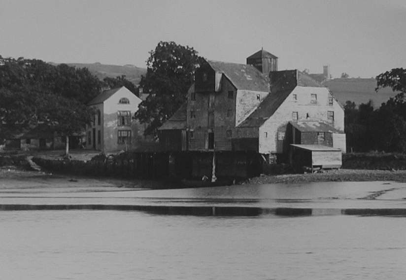
Budshead Mill in its heyday. The tower of St Budeaux Parish Church can be seen on the skyline to the right of the picture. (Photograph from Steve Johnson's collection of images of Plymouth's heritage) |
St Budeaux Develops
With the demand for more space for dwellings and the improvement of communiciations with Plymouth and Devonport, St Budeaux developed on the lower ground in the south of the parish. Creeks at Weston Mill and and also at Keyham had prevented direct access to Plymouth and Devonport by road. These were bridged or filled in but as late as 1901, the head of Weston Mill Creek was bridged only by a wooden bridge unsuitable for heavy traffic.
|
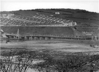
A photograph obtained from Steve Johnson's Plymouth Heritage website. I was puzzled by the viewpoint, but I think the railway bridge in the backround carries the old LSWR line, bridging Weston Mill creek upstream of the original GWR crossing. This dates the photo to after 1890, when the LSWR line was brought through from Lydford to Plymouth and the LSWR's St Budeaux railway station opened. |
The Devonport tram service did not extend over this bridge and a shuttle service to Saltash Passage was operated by tram cars stationed on the far side of the bridge. For many years, the shed in which the two tram cars were kept, converted into a garage, was a feature of the area. Later, the embankment across the creek was completed, at Camel's Head as the place was named after a public house which stood there, and a through tram service established between Devonport and Saltash Passage.
|
A postcard from my collection showing the development of lower St. Budeaux. Shops and houses start to be built in St. Budeaux Square and up the hill, along the line of Victoria Road. Fields start to disappear under brick. Along the skyline, is the 'Commons' on the original road to Saltash Passage, now largely superseded by a lower road running through the Square. |
The improvment in communcations allowed the development of the area known as St. Budeaux Square. As early as 1891, an hotel named the Trelawney (after the family who owned much of the land in the area) had been built here, at the junction between the London & South Western Railway halt (later known as Victoria Road) and the lower road to Saltash Passage. The Great Western Railway had also passed through this area on its route into Cornwall via the Royal Albert Bridge. However, surprisingly there was no halt constructed on the GWR at this point until 1904, when Ferry Road was opened.
The centre of development in the parish now moved from the church and rural economy at the top of the hill to the suburban development spreading up the hill, which now became known as Victoria Road. The original centre of the parish now started to be called Higher St Budeaux. According to some accounts, the inhabitants of 'lower' St. Budeaux were often treated to a hail of stones from the youth of higher St. Budeaux when leaving church on a Sunday evening, a practice which apparently also greeted travellers arriving at Saltash on the ferry from Saltash Passage.
|
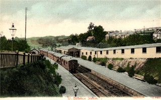
This postcard from my collection shows the first station constructed in St. Budeaux Square by the London and South Western Railway, later known as Victoria Road to distinguish it from the Great Western Railway halt, later known as St Budeaux Ferry Road, on the road to Saltash Passage. The GWR and LSWR intersected just west of the Square, with the LSWR running under the GWR; a link between the two lines was constructed at St. Budeaux in 1941. |
Acknowledgements
These notes have been assembled from the work of several sources, as follows.
- H. Montagu Evans, whose lecture entitled 'St. Budeaux - Its Manors and First Church' was printed in the 'Transactions of the Plymouth Instition', 1913
- Marshal Ware, who wrote 'St. Budeaux - Yesterday's Village' and 'The Ancient Parish of St. Budeaux'
- Ian D. Merry, who wrote 'The Shipping and Trade of the River Tamar'
- An article contained in 'Glancing Backward', a handbook published by the St. Boniface Church Extension Committee in 1963, the Golden Jubilee for the Church (1913 -1963); research for this article is credited to Mr S. Greenwood.
- 'Trewman's Exeter Flying Post, or Plymouth and Cornish Advertiser', archived and indexed at the Westcounty Studies Library, Exeter
- The series of images of Plymouth's heritage published on the web by Steve Johnson
- Tithe Map for St. Budeaux, held at the Devon Record Office
- St. Budeaux Tithe Apportionment, available on line via the Devon County Council Tithe Apportionment Transcription Project
- Scanned images from my own collection of postcards
I have used some of my own photographs as indicated for which I claim copyright
If anyone believes that their copyright has been infringed, please contact me and I will remove the offending items
©Roger Donne 2003-2014
Updated 5 July 2014