Roger Donne’s Miscellany |
|
|
About This Site |
Cycling |
Family History |
Contact Me |
Site Map |
Links |
Tenants and Tenements in the Manor Of Godolphin, 1788
Manor of Godolphin Estate Map, 1788
The Cornwall Record Office holds the Estate Map for the Manor of Godolphin, dated 1788, which delineates to field level the holdings of various named tenants. I have Donne family connections with the area known as Kerthen Wood, in the parish of Crowan, although the manorial lands actually straddle the parish boundary between Crowan and St Erth; the boundary is formed by Kerthen Water for some of its length. I have photographed the Estate Map at Cornwall Record Office, and I have tried to trace the original tenements on later Ordnance Survey maps; my latest project is an attempt to use the resources provided by Google Earth to provided a mapping of these tenements onto the satellite imagery provided by Google Earth. Remarkably, the 1788 field boundaries are still largely preserved in the landscape; even where hedges have been removed to form larger fields the original features are often recognisable in the cropmarks.
Each holding generally had a dwelling associated with it and these dwellings and any outhouses are indicated on the original plan. In some cases, the sites of these dwellings are still in use today; however, many have disappeared as the holdings have been amalgamated into larger farms.
Google Earth
Google Earth is a remarkable resource available free, which provides satellite imagery of the Earth's surface. To use Google Earth requires the download and installlation of the Google Earth viewer. It is only likely to perform satisfactorily with a broadband connection
The Tenants and the Tenements
The list of tenants is taken from the 'Explanation' shown on the Estate Map. If you have Google Earth installed, this KMZ file will open Google Earth and zoom to the particular area of Cornwall at Kerthen Wood, Crowan. Once installed, the features shown can be investigated in more detail by turning off the display of unwanted markups and enlarging the area. For those without Google Earth, this overview shows the area of Kerthen Wood. The yellow line shows the boundary between the parishes of St Erth and Crowan.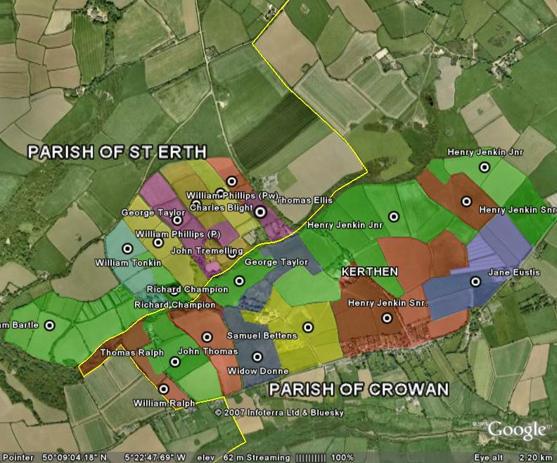
The table below shows a list of the tenants and the location of their holding. A link is provided to a snapshot of the Google Earth mapping showing the location of the tenement. This information can also be obtained more flexibly from the use of the KMZ file and Google Earth. The list of tenants is taken from the 'Explanation' or key shown on the Estate Map and is shown in full although map images are provided only for the region of Kerthen and Kerthen Wood.
| William BARTLE | At Kerthen Wood |
| Charles BLIGHT | At Kerthen Wood |
| Samuel BETTENS | At Kerthen Wood (Note 1) |
| Richard CHAMPION | At Kerthen Wood (Note 2) |
| Widow DONNE | At Kerthen Wood |
| Thomas ELLIS | At Kerthen Wood |
| Jane EUSTIS | At Kerthen |
Richard FAULL |
At Paul's Down |
Arthur FOX |
Harrington Wood |
| HENRY JENKIN Snr. | Higher Kerthen |
| Henry JENKIN Jnr. | Lower Kerthen |
| William PHILLIPS (P) | At Kerthen Wood (denoted by 'P' on original map) |
| William PHILLIPS (Pw) | At Kerthen Wood (denoted by 'Pw' on original map) |
| Thomas RALPH | At Kerthen Wood |
| William RALPH | At Kerthen Wood |
John RALPH and John RODDA |
At Paul's Down |
| Benjamin and John ROWE | Trenadras Estate |
| George TAYLOR | At Kerthen Wood |
| John TREMELLING | At Kerthen Wood |
| William TONKIN | At Kerthen Wood |
| John THOMAS | At Kerthen Wood |
Notes
- Samuel BETTENS' holding is identified in othr leases as being previously held by Richard DONNE by a lease dated 1768
- Richard CHAMPION's holding is identified in an indenture (CRO RH/1/1930) as being previously held by William DONNE (believed to have been the husband of the Widow DONNE). Richard CHAMPION's land is in two parts; the indenture gives him right-of-way through 'the townplace now (1777) in the possession of William Tonkin'.
Disclaimer
The copyright of the original 1788 Estate Map is claimed by the Cornwall Record Office. As far as I am aware, the images and information published here do not infringe any rights. However if any rights have been infringed inadvertently, please contact me and I will remove the offending material.
The information is provided for the use of fellow genealogical reasearchers of the families of St Erth and Crowan in Cornwall and is not to be used for any commercial purpose whatsoever.
If you have any comments, please use the email form
This page last updated on 7 January 2008